Record-Breaking Chill Approaching New Jersey: What You Need to Know
A severe Arctic blast is on its way to the East Coast, with New Jersey bracing for dangerously low temperatures. While the state may dodge a significant snowstorm this time, existing bone-chilling conditions and gusty winds could create an apparent temperature of around 0°F. According to forecasters at AccuWeather, cold weather alerts have been issued across many regions in the U.S., marking New Jersey as a prime target for “life-threatening cold air,” which is expected to persist throughout the remainder of the week.
Current Weather Forecast for New Jersey
As light snow begins to blanket parts of Southern New Jersey—anticipating accumulations of one to two inches from Wednesday through Thursday morning—the experience might become increasingly uncomfortable due to wind gusts soaring between 25 and 35 mph. AccuWeather advises that residents prepare appropriately when venturing outdoors, as temperatures are projected not to rise beyond the mid-20s °F on Thursday.
The “RealFeel Temperature,” a term coined by AccuWeather indicating how frigid it actually feels outside based on multiple factors such as humidity and wind speed, is predicted to hover between 0°F and 10°F in various parts of the state early Thursday morning. Northern areas could even encounter wind chills dipping into single digits.
Coming Relief from Frigid Conditions
Fortunately, relief from this frigid spell is anticipated over the weekend. Expect sunnier skies paired with diminishing winds. For South Jersey residents eager for warmth, Friday should bring daytime highs above freezing—a welcome sight after days of severe cold—while northern regions may see similar improvements by Saturday.
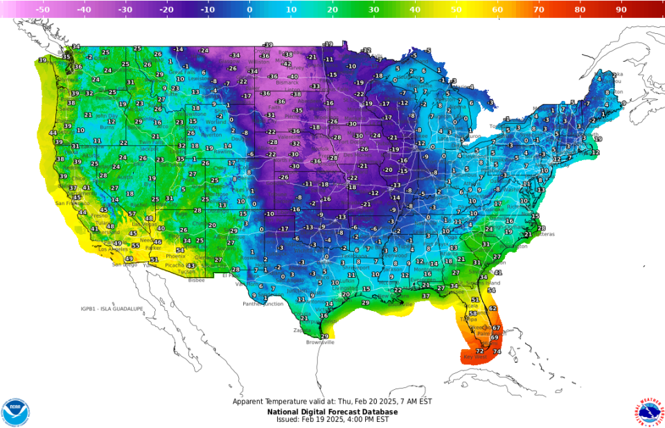
National Weather Service’s map indicating apparent temperatures expected in New Jersey.
Historical Context: A Look Back at Extreme Cold
Despite feeling exceptionally frigid today, history reveals that temperature records in New Jersey have plummeted far below current conditions. The state’s coldest month recorded was February 1934 when average statewide temperatures reached just 17.2°F; extraordinarily low readings included -34°F reported in River Vale—a figure corroborated by Climatologist David Robinson.
Those interested in historical extremes will note that Newfoundland within West Milford experienced -25°F on February 16th during 1943; moreover, Sussex Borough saw an astonishing temperature drop down to -23°F back on February 9th,1967.
Average Climatic Conditions for February
Although forecasts indicate chilly weather ahead this week without any record-breaking lows projected anytime soon, it’s important to assess standard climatic averages for February across different areas of New Jersey:
- Typical high temperatures during this month fluctuate between upper-30s °F and mid-40s °F depending predominantly upon location.
- Conversely, average low figures range from roughly +29 °F near Salem County down towards +22 °F recorded within Sussex County according to studies compiled by Weatherspark.com.
New Jersey generally enjoys average daily highs around +40.4 degrees Fahrenheit throughout February—a statistic maintained since data collection began back in1895—while lower averages sit at approximately +21.9 degrees over these last131 years according data analyzed by teams at Rutgers University’s NJ State Climatologist Office.
Lori Comstock reports extensively about weather patterns affecting Mid-Atlantic states through her work associated with prominent journalism organizations.
This article was derived from NorthJersey.com coverage focusig on urgent updates regarding exceedingly harsh winter environments anticipated within NJ our region’s immediate future succeeding altering atmospheric circulations resulting whimsically troubling climate influence writ large!


