Severe Flooding Strikes Western North Carolina After Hurricane Helene
 destructive path through Florida. This intense rainfall compounded what had already been a wet two-day period, saturating soils and causing local rivers to swell dramatically. These conditions created an environment ripe for devastating flash floods.
The Impact on Communities
The flooding brought chaos to local towns as raging waters submerged neighborhoods, inundated agricultural land, and dislodged structures from their foundations. Critical power lines and water infrastructure were destroyed in many areas. Although cloud cover has hindered extensive optical imaging from NASA satellites during this period, some information was gleaned from various sensors including those on the Landsat 8 and Landsat 9 satellites as well as the ESA’s Sentinel-2.
A Glimpse Through Satellite Eyes
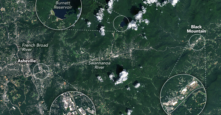
An image captured by Sentinel-2’s MultiSpectral Instrument on October 2 displayed significant flooding along both the French Broad River and Swannanoa River near Asheville. In stark contrast, historical data gathered before these events showed these rivers at normal levels just days earlier (August 30). The difference is striking—depicting life before extremes disrupted ordinary existence.
 local reports from Asheville Citizen-Times. With utilities crippled on September 29th—with Black Mountain reportedly out of power—and roads rendered impassable according to ABC9 news reports—the region struggled for basic resources amidst rising desperation.
A Record-Breaking Rainfall Event
This unprecedented deluge led some meteorologists to classify it as a “1-in-1,000-year flood.” The combined precipitation totals reached alarmingly high figures; Yancey County recorded staggering amounts with one weather station indicating nearly 31 inches (78 cm) over a mere three days between September 25-27 according to the National Weather Service’s Cooperative Observer Program data.
![]() Tags:climate changeextreme weatherflash floodsnatural disastersNorth CarolinaTheNewsGuyUSA News
Tags:climate changeextreme weatherflash floodsnatural disastersNorth CarolinaTheNewsGuyUSA News


