Long-range weather forecasts are always updated gradually as we get closer to the time period of the forecast. The winter forecast has just been updated by NOAA’s long-range forecasting experts. There’s a meaningful tweak to Michigan’s winter temperature forecast.
The tweak to the December to February temperature forecast for Michigan is to a slightly warmer scenario than the winter forecast issued one month ago. NOAA does update what they call the seasonal forecasts, which are three-month forecasts. They give us an update once a month. Yesterday the updated extended forecasts were issued.
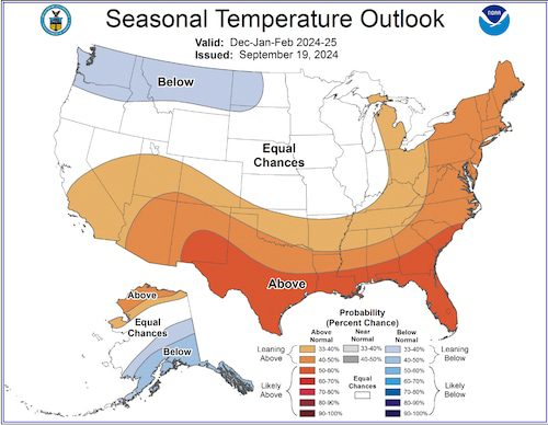
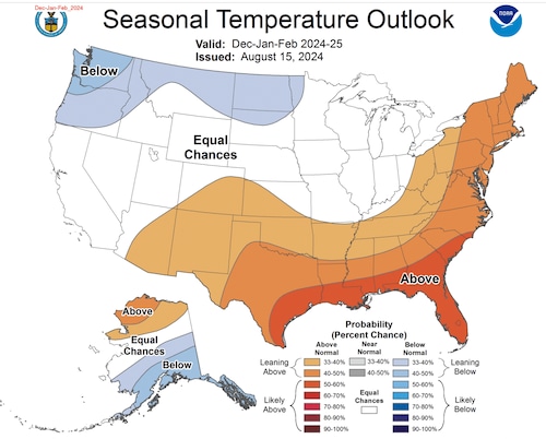
Here’s the newest December to February temperature forecast. Just below the latest forecast I have the previous forecast for you to compare the changes.
Notice much of Lower Michigan and the eastern Upper Peninsula have been shifted into an area that leans toward having a warmer than normal winter. This first level into warmer than normal temperatures would imply it will be a slightly warmer than normal winter, if this forecast verifies as correct.

Latest issuance of winter temperature forecast, issued September 19, 2024NOAA
You can see the previous forecast last month had NOAA indicating it thought our winter temperatures could fall either to just slightly colder than normal to just slightly warmer than normal. Of course in that type of forecast a near normal temperature for winter is the most likely scenario.

Previous issuance of winter temperature forecast, issued August 15, 2024NOAA
Now NOAA leans toward us having a slightly warmer than normal winter.
So why the change? There’s a great reason. La Niña was one of the conditions expected to develop now or soon and influence our winter weather. La Niña is the opposite of El Niño. La Niña is said to be occurring when a large part of the Pacific Ocean along the equator turns colder than normal.
Well, La Niña is being slow to develop. The newest computer model projections produce only a weak La Niña and for only a short duration. The weak La Niña won’t produce the weather effects a strong La Niña would have produced. A strong La Niña often makes a cold winter for the Pacific Northwest into the northern Plains. While the really cold sign fades in Wisconsin, we find the cold air is close enough to occasionally leak into Michigan. With a weak La Niña we may not see a large pool of very cold air just to our northwest.
So for the winter temperature forecast we go back to the 800-pound gorilla of extended forecasting now – global warming. With warmer oceans and rapidly warming polar regions, it’s just harder to have sustained BELOW NORMAL TEMPERATURES. Sorry I have to shout at you. I do this to protect myself. This doesn’t mean you might not think it’s cold. I don’t know what you call cold. But to have a long-lasting several month period of extreme cold is going to be very hard to do in the current cycle of a warming globe.
What does this new forecast mean in real useful terms? It means we likely have several stretches of a few days to a week when afternoon temperatures warm above freezing in the middle of winter. This means if we get nasty ice packed roads from a snowstorm or ice storm, it will melt off in a week or two.
The La Niña was predicted to last into early summer and then fade to what we call neutral conditions- neither El Niño or La Niña going on. Now the latest models show the La Niña ending sometime between February and April.
You’ll still need your winter coat based on this latest winter forecast update. You just might not need it every day this winter.
Source link : http://www.bing.com/news/apiclick.aspx?ref=FexRss&aid=&tid=66edb53582f44433a602559d4553dafb&url=https%3A%2F%2Fwww.mlive.com%2Fweather%2F2024%2F09%2Fupdated-winter-temp-forecast-just-got-warmer-for-michigan-heres-why.html&c=5147096065947078518&mkt=en-us
Author :
Publish date : 2024-09-20 06:36:00
Copyright for syndicated content belongs to the linked Source.


