

The last rounds of showers and thunderstorms associated with the North American monsoon are on deck as a big change in the weather pattern will soon end the tropical influx of moisture over the southwestern United States and sweep away summer-long heat in the deserts, AccuWeather meteorologist say.
The clock is ticking on the North American monsoon and the annual shift of winds that transport moisture into the western U.S.
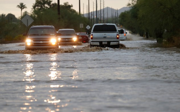

Static Phoenix Flash Flood AP Monday Jul 9
Vehicles in the Phoenix metro area navigate a flooded street that accompanied severe storms on Monday, July 9, 2018. (AP Photo/Ross D. Franklin)
Even though a diminishing tropical storm that reached the Gulf of California will not survive the trip into the Southwest, Ileana will lose wind intensity and become impossible to track later this weekend to early next week as it moves inland over western Mexico. Most of its moisture will be driven into the mountains of Mexico. Still, some tropical moisture will be drawn into the deserts, valleys and mountains of New Mexico, Arizona, and Colorado.
As this moisture comes into contact with the lingering effects of the North American monsoon and its leftover spotty showers and thunderstorms, it will give the rainfall and the thunderstorm activity a boost from this weekend to early next week.


The result will be an uptick in the number of downpours that can trigger dangerous flash flooding and gusty thunderstorms. Flash flooding may occur in remote areas, but also in Phoenix, Flagstaff and Tuscon, Arizona; Durango, Colorado; and Gallup, New Mexico, to name a few cities and towns in the region. Hikers venturing in the canyons should exercise caution. Aroyyos may rapidly fill with water. Mudslides and other debris flows can occur.
Tropical moisture is not all that will help to enhance the showers and thunderstorms.
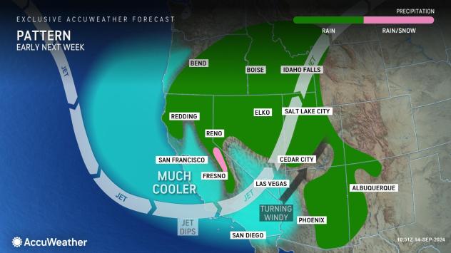
A major shift in the jet stream will take place into next week. The jet stream will dive unusually far south for September and result in a weather pattern much more typical of March or April–that means a big sweep of cool air will occur and will only be negated by the effects of the lingering warmth of the landscape and the mid-September sun.

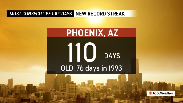
This summer has delivered a record number of consecutive days with triple-digit Fahrenheit highs in Phoenix. As of Friday, that number was 110, with the potential to add one to three more days to the tally this weekend to early next week. The old record of 76 consecutive days from the summer of 1993 of 100 degrees or higher was shattered weeks ago.
By the middle of next week, Phoenix’s highs near or above 100 will be swapped for highs in the lower 90s. The last time that happened consistently was in early May.

Highs at or above 100 in Palm Springs, California, will be replaced with highs in the 80s for the first time since May. Temperatures could even dip to record-challenging low levels in the 50s Monday night.
GET THE FREE ACCUWEATHER APP
It may get so cool by the middle of next week that temperatures do not rise out of the 70s for a day or two in Las Vegas, which is more typical of early to mid-April.
Highs will be in the 70s around Los Angeles or about 10 degrees below the historical average. Throw in a breeze at times and AccuWeather RealFeel® Temperatures may dip into the 60s during the day.
Stiffer than usual breezes will add to the chill around San Francisco, so highs in the 60s may feel more like the 50s or like a “June gloom,” but with some sunshine thrown in.
The cool pattern will be even more dramatic in the mountains.
While not the first snowflakes of the season, thanks to a couple of days of chilly conditions in late August, this outbreak may be much more impressive in terms of the snow produced over the Sierra Nevada.
It is possible that a few inches of slushy snow will accumulate on the high country from later Sunday night to Monday.


Most roads will be just wet, but the visibility may slow travel as gusty winds are likely to accompany the snow. While some chilly, wind-driven showers may occur over the Grapevine, snow is not expected just yet.
A widespread price to pay for the shifting weather pattern will be strong gusts over the Southwest region, especially from Sunday to Monday. Gusts ranging between 60 and 80 mph are possible over the passes in extreme cases and may reach 100 mph over some of the ridges and peaks. Over the interior valleys, gusts of 40-60 mph are likely but unusual for mid-September in a non-Santa Ana setup with winds shifting from south to west.
The gusts will kick up dust in areas where little or no rain falls, which will be many of the California, Nevada, and Arizona deserts. There will be a risk of vehicle rollovers.
Strong winds will also make firefighting efforts extremely difficult due to the ongoing blazes. Even though humidity levels will climb as temperatures dip, the ongoing windy conditions can still pose a tremendous challenge.


Portions of Arizona, New Mexico and Colorado will be thoroughly drenched by showers and thunderstorms into Monday, but lightning strikes on the edge of the storms could spark new blazes.
As the strong southwest winds shift to the west and ease somewhat, the North American monsoon, with its humid air and thunderstorm activity, will end, and a more progressive fall weather pattern will begin.
Want next-level safety, ad-free? Unlock advanced, hyperlocal severe weather alerts when you subscribe to Premium+ on the AccuWeather app. AccuWeather Alerts™ are prompted by our expert meteorologists who monitor and analyze dangerous weather risks 24/7 to keep you and your family safer.
Source link : http://www.bing.com/news/apiclick.aspx?ref=FexRss&aid=&tid=66e5dc07966e45d7a241610e0b06ea24&url=https%3A%2F%2Fwww.aol.com%2Fweather%2Fbig-cooldown-rain-snow-wind-155249638.html&c=4175217793193126864&mkt=en-us
Author :
Publish date : 2024-09-14 07:52:00
Copyright for syndicated content belongs to the linked Source.


