
![]()
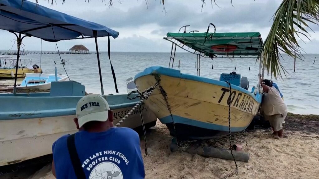
Preparations underway in the Caribbean as Tropical Storm Helene nears
High winds and rough surf was seen around the Caribbean as experts say Tropical Storm Helene will strengthen into a hurricane.
TALLAHASSEE, Fla. − Helene reached hurricane status Wednesday and was forecast to grow more powerful and dangerous before making landfall late Thursday on Florida’s Gulf Coast as a devastating, Category 3 hurricane.
The National Hurricane Center said Helene would rapidly strengthen over the eastern Gulf of Mexico before making landfall while driving winds of 120-125 mph − and warned that “upward adjustments to the forecast intensity” could be required as the storm closes in.
The highest landfall probability was somewhere along the eastern part of the Florida Panhandle − possibly the Big Bend area, the curve of Florida’s peninsula around the Gulf of Mexico − late Thursday, AccuWeather forecasters said. Near where Helene makes landfall, general rainfall of 8-12 inches is expected, with 2 feet of rain possible in isolated areas.
More than 42 million people in Florida, Georgia and Alabama were under hurricane and tropical storm warnings, the National Weather Service said.
Helene could also become Tallahassee’s worst wind event in recorded history as 100 mph winds blast the Florida capital. Ryan Truchelut, founder of WeatherTiger and a hurricane forecaster for the USA TODAY NETWORK-Florida, said Helene is a storm without precedent.
“Helene stands toe-to-toe with any of the threats that Florida has faced over the past 10 years or indeed really over hurricane history,” Truchelut said.
A month ago, Jody Griffis rode out Hurricane Debby in his Cedar Island home along the Big Bend coast. But as he secured his stilt home with shutters and siding Wednesday, he told USA TODAY he will heed the local evacuation order issued ahead of Helene.
“My gut is telling me to get out,” he said.
Storm tracker: See projected path of Tropical Storm Helene set to become a hurricane
Developments:
∎ Tampa International Airport said it will suspend operations at 2 a.m. Thursday because of the hurricane. The airport plans to reopen “when safe to do so.” The smaller, nearby St. Pete-Clearwater Airport will be closed Thursday and is scheduled to reopen Friday, according to its website. Orlando International Airport said on X that it remains open but some flights could be delayed or cancelled for weather-related reasons.
∎ While U.S. flights weren’t seeing a major impact early Wednesday, 12% of flights to Cancun, Mexico, had been canceled and another 16% delayed as of 1:30 p.m. ET, according to online flight tracker FlightAware. Elsewhere, airlines have issued travel waivers, allowing customers to rebook flights along the hurricane’s path without penalties, though cities, dates and terms vary widely. Details here.
∎ The Tampa Zoo said it will close its door to the public Thursday and take measures to protect the animals from the approaching hurricane.
∎ The University of Florida cancelled classes for Thursday, joining Florida State and Florida A&M universities, whose closures will last through the weekend.
∎ Helene is the fifth hurricane of the 2024 Atlantic season, about the average number for the date, according to Colorado State University hurricane researcher Phil Klotzbach. A typical season sees a total of seven hurricanes.
Helene’s explosive forecast one of the ‘most aggressive’ in hurricane history
Griffis, 57, said he planned to leave with his wife for his brother’s house Thursday morning, likely after a long night of fortifying his own home.
“Everything that I have of value will go with me,” he said, describing family heirlooms and photo albums. “If this thing gets up to 135-140 miles an hour, I don’t know if my house can take it.”
Steve Brown, 72, who lives just a few yards from the gulf in Cedar Island, spent the last 24 hours moving outdoor furniture into his home, which sits on stilts 21 feet above sea level.
Under a countywide evacuation, he plans to leave with his wife, Cindy, and their cat, Max, to a friend’s home in the nearby city of Perry. “People around here are busy,” said the retired school teacher. “It’s not a frenzy. Everybody’s been through this before, so they have a plan and they’re just executing it.”
Rapid intensification is when a hurricane’s winds accelerate by 35 mph or more within 24 hours. Computer models indicate a high chance Helene will experience rapid intensification over the next 24 hours, Robbie Berg, a specialist at the hurricane center, wrote in a Wednesday morning forecast.
Helene will be moving through an environment very conducive to intensification, with low wind shear and much warmer than normal sea surface temperatures. While the official forecast predicts sustained winds up to 125 mph on Thursday, Berg said those winds could be stronger if Helene “rapidly intensifies more than forecast.”
In Sarasota, Florida, hundreds of miles from where forecasters predict Hurricane Helene will come ashore, residents prepared for the storm Wednesday. Rick Munroe, owner of Sun Garden Cafe, brought in patio furniture and stacked sandbags in front of the doors. A long stretch of Florida’s coast, including western Sarasota, could be exposed to storm surge of up to 7 feet, according to forecasters.
“If you don’t take them serious,” he said, speaking about hurricanes, “then you’re foolish or you just moved here.”
Paul Samuel, a local general contractor, said many of his clients are similarly concerned about the hurricane. One homeowner had him move much of the furniture on the bottom floor of their home to the second floor. Samuel plans to wrap up several projects by the end of the day, including one that requires the installation of seven windows and doors before the winds and water pick up.
“It’ll be airtight by tonight,” Samuel said.
– Sarasota Herald-Tribune
Helene was centered about 85 miles east-northeast of Cozumel, Mexico, early Wednesday, the hurricane center said. The storm was driving sustained winds of 80 mp, and was moving north-northwest at 10 mph. AccuWeather forecasters were predicting Helene could briefly reach Category 4 strength while still in the Gulf, which would mean maximum sustained winds ranging between 130 and 156 mph.
Tornadoes were possible late Wednesday on the western Florida Peninsula and southern Alabama, the hurricane center said. The risk of tornadoes expands Thursday across Florida and into parts of Georgia and South Carolina.
At least 22 Florida counties have some form of evacuation order in effect.
Three counties in the Big Bend coast, where storm surge could reach heights of 15 feet, issued mandatory evacuation orders for all residents and visitors in its jurisdiction. Officials in Wakulla, Franklin and Taylor counties – home to about 69,000 people – warned residents of the danger posed by the storm and urged them to take it seriously.
“Hurricane Helene is predicted to be a catastrophic and life threatening storm system,” the Taylor County Sheriff’s Office said on Facebook. “This system will be unlike anything we have experienced to date. A curfew is effective from sunset to sunrise. Repeat, this is a MANDATORY EVACUATION ORDER for everyone.”
Leon County, home to Tallahassee, ordered the evacuation of residents from mobile and manufactured homes because of the threat of high winds. “Seek shelter no later than 8 a.m. Thursday,” an emergency alert from the county read.
Seventeen other counties stretching across the western coast of the state, from the panhandle to just south of Sarasota, have announced mandatory or voluntary evacuations, according to the Florida Division of Emergency Management. Across the state, officials announced closures of government offices and facilities as well as public schools and several major universities.
![]()
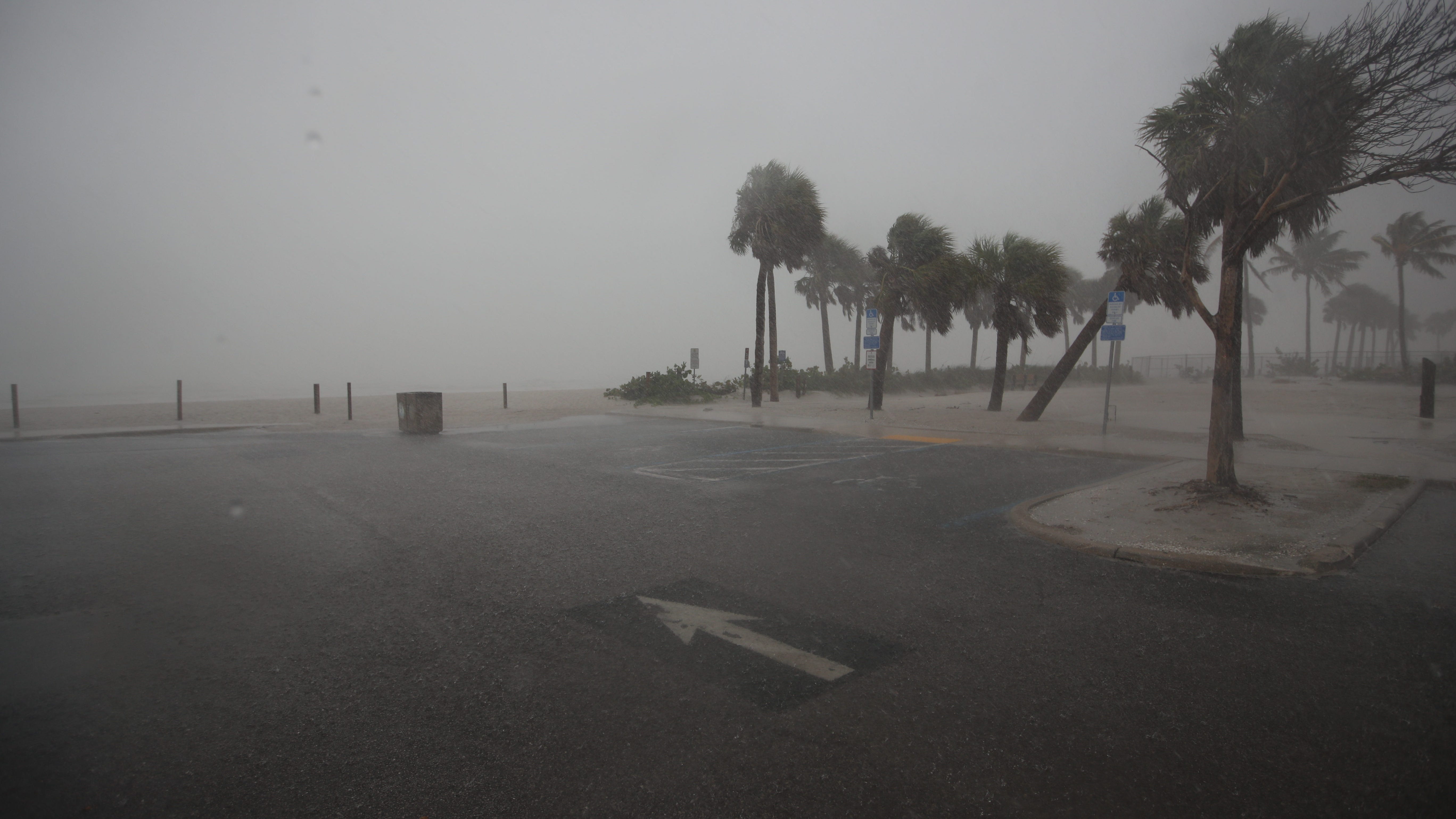
Storm approaches FMB as Hurricane Helene strengthens in Gulf of Mexico
Hurricane Helene approaches Fort Myers Beach in the Gulf of Mexico. Helene is expected to hit the Big Bend area of the Florida Panhandle on Thursday.
Rick Minor, a county commissioner in Leon County, which encompasses Tallahassee, urged residents to take the approaching storm seriously.
In an email to constituents on Tuesday night, Minor said he was briefed by Leon County Emergency Management officials, who said that if the current track holds, Leon County will suffer a direct hit.
“On Thursday we’ll face about six hours of sustained winds of 74-110 mph, leading to thousands of downed trees, more than a hundred blocked roads, hundreds of damaged structures, and many, many days of extended power outages,” he said. “But we mustn’t panic — fortunately, we all have enough time to carefully plan and prepare.”
According to the National Weather Service in Tallahassee, Helene could render some areas “uninhabitable for weeks or months.”
Widespread power and communications outages also are expected for prolonged periods.
For those living in Wakulla, Franklin and Taylor counties, National Weather Service forecasters offered a grim wakeup call hours after emergency managers ordered all county residents to evacuate: “This forecast, if realized, is a nightmare surge scenario for Apalachee Bay. Please, please, please take any evacuation orders seriously.”
A hurricane warning was in effect for Cabo Catoche to Tulum, Mexico, including Cozumel. Additionally, there was a tropical storm warning in effect for Rio Lagartos to Cabo Catoche, the U.S. hurricane center said. On the forecast track, the center of Helene was expected to move across the eastern Gulf of Mexico later Wednesday and Thursday, according to the hurricane center. Helene is expected to produce total rain accumulations of 4-8 inches over western Cuba, the Cayman Islands and the northeast Yucatan Peninsula, with isolated totals around 12 inches, bringing a “risk of considerable flooding,” according to the hurricane center.
− Gabe Hauari
Along with powerful wind speeds and high rainfall amounts, another deadly hazard is a major concern for the western coast of Florida: storm surge.
In the open ocean, hurricane winds push water toward the center of the storm and instead of piling up, the water spirals downward and flows outward.
As the water is pushed downward, some is pushed out to sea and some is pushed toward the coast. As the storm approaches land and shallow water, the ocean floor blocks the outflowing water, causing the ocean to surge onto land.
Forecasters predict the Helene will wallop the Big Bend coast of Florida with a surge of water as high as 15 feet, while other coastal areas, such as Tampa Bay, could see 8 feet of water. The storm is expected to rapidly intensify into a major hurricane as it churns over the warm waters of the Gulf.
Among the factors making coastal communities along the Gulf of Mexico more vulnerable to piling water is its continental shelves that extend well over 100 miles from the shore. On the Atlantic coast, narrower shelves with steep slopes produce a lower surge.
– Javier Zarracina, Ramon Padilla, Stephen J. Beard, Dinah Voyles Pulver
Florida Gov. Ron DeSantis said Floridians should prepare for a potential major hurricane after he expanded his state of emergency declaration to 61 counties.
“Right now you do have time, so take advantage of that time,” DeSantis said. “Review your plan and make sure you’re executing your hurricane preparedness plan.”
“Don’t get wedded to these cones. You could be out of the cone and still have major impacts.”
Helene, expected to intensify rapidly, prompts hurricane warning for Florida Gulf Coast
U.S. oil producers scrambled Monday to evacuate staff from Gulf of Mexico oil production platforms as the second hurricane in two weeks was predicted to tear through offshore oil-producing fields.
Oil companies BP, Chevron, and Shell have begun evacuating offshore staff, and several have paused some production. Just two weeks ago, Hurricane Francine roared across the Gulf of Mexico, peaking as a Category 2 with 100-mph winds as it made landfall in Louisiana.
The storm is forecast to become a major hurricane, a Category 3, before approaching the Florida Gulf Coast on Thursday, the National Hurricane Center said.
According to Colorado State University hurricane researcher Phil Klotzbach, eight major hurricanes have made landfall in Florida since 2000: Charley and Jeanne in 2004; Dennis and Wilma in 2005; Irma in 2017; Michael in 2018; Ian in 2022; Idalia in 2023.
Contributing: Doyle Rice, USA TODAY; William L. Hatfield, Tallahassee Democrat; Steve Patterson, Jacksonville Florida Times-Union; Kim Luciani USA TODAY NETWORK – Florida; Reuters
Source link : http://www.bing.com/news/apiclick.aspx?ref=FexRss&aid=&tid=66f45d12036f4a7d9c5a19970c5e23fd&url=https%3A%2F%2Fwww.usatoday.com%2Fstory%2Fnews%2Fnation%2F2024%2F09%2F25%2Fhelene-storm-hurricane-path-forecast-live-updates%2F75369769007%2F&c=1102518810800006407&mkt=en-us
Author :
Publish date : 2024-09-25 06:58:00
Copyright for syndicated content belongs to the linked Source.