![]()
Tropical rainstorm to strengthen into hurricane, targets US Gulf Coast
A tropical rainstorm is currently developing over the Caribbean Sea. The storm is expected to strengthen into a hurricane and travel north, targeting the U.S. Gulf Coast before the end of the week.
(This story was updated to add new information.)
Hurricane and storm surge watches covered much of the Gulf Coast of Florida on Tuesday morning as a system churning in the Caribbean Sea was expected to strengthen rapidly into a powerful hurricane.
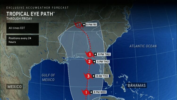
The National Hurricane Center predicted the storm – soon to be named Helene – will reach winds of 115 mph before landfall, making it a major Category 3 storm, experts say. Forecasters warned the storm could bring life-threatening storm surge, hazardous winds and heavy rain.
The system is expected to intensify into a hurricane by Wednesday and make landfall on Thursday, according to the hurricane center.
“Everyone along the Florida Panhandle and Big Bend region needs to be prepared for hurricane impacts,” said AccuWeather Lead Hurricane Expert Alex DaSilva, adding that the setup has the potential to become the strongest hurricane landfall in the U.S. this season.
Developments:
∎ Florida Gov. Ron DeSantis on Monday declared a state of emergency for 41 counties along and near Florida’s Gulf Coast because of threats from the storm. The declaration said there’s a significant risk of storm surge and flooding, particularly in areas still recovering from the elevated water levels left behind by Hurricane Debby.
∎ If the storm makes landfall as a hurricane, it would be the fourth landfalling hurricane in the mainland U.S. this year, joining Beryl, Debby, and Francine.
The soon-to-be-named storm was located in the Caribbean Sea early Tuesday, where it’s forecast to bring dangerous conditions such as flooding and storm surge across the Cayman Islands, the Yucatan Peninsula and Cuba through the midweek.
The storm was located 150 miles west of Grand Cayman and 205 miles south-southeast of the western tip of Cuba, according to the National Hurricane Center’s 8 a.m. update. With maximum sustained winds of 35 mph, the system was moving northwest at 9 mph.
On its current track, the center of the system is expected to push across the northwestern Caribbean Sea on Tuesday night before emerging over the eastern Gulf of Mexico on Wednesday and pushing toward the Southeastern U.S.
The system could dump 4 to 8 inches over western Cuba and the Cayman Islands with isolated totals around 12 inches, the hurricane center said, warning of “considerable flooding.” Over the eastern Yucatan Peninsula, 2 to 4 inches of rain was expected with isolated totals over 6 inches. Other threats include storm surge and heavy wind gusts.
“Hurricane conditions are possible within the watch areas in Cuba and Mexico by early Wednesday,” the weather service said. “Hurricane conditions are possible within the U.S. watch areas late Wednesday and early Thursday.”
In a morning update from the National Hurricane Center, meteorologists issued a hurricane watch for the majority of the Gulf Coast of Florida, running from Englewood, just south of Sarasota, to Indian Pass, in the Big Bend region. Cities including St. Petersburg and Tampa Bay are under hurricane watches.
“A hurricane watch means that hurricane conditions are possible within the watch area,” according to the hurricane center. “A watch is typically issued 48 hours before the anticipated first occurrence of tropical-storm-force winds, conditions that make outside preparations difficult or dangerous.”
Some areas of the state are under tropical storm watch while a storm surge watch was issued across most of the Gulf Coast, indicating that “there is a possibility of life- threatening inundation, from rising water moving inland from the coastline,” during the next 48 hours, according to the weather service.
The tropical system in the western Caribbean may not look like much yet, but don’t be fooled. History has shown the Gulf of Mexico can be a pressure cooker, turning systems like this one from wimpy windstorms to devastating monster storms almost overnight under the right conditions.
The storm is forecast to strengthen with potential explosive force in the Gulf. It’s called rapid intensification and it’s happened before. In fact, most of the worst hurricanes in history have experienced rapid intensification, Ken Graham, the National Weather Service director, has said in interviews with USA TODAY.
Read more: Will Hurricane Helene emerge like a monster from the Gulf?
All of Florida’s Big Bend and parts of southwestern Georgia have at least a moderate risk of excessive rainfall over the next five days, according to the Weather Prediction Center. Elevated stream levels still lingering after Hurricane Debby in August are expected to contribute to the flood risk.
The official forecast calls for rainfall of 4 to 6 inches along Florida’s west coast as well as in the Panhandle, and amounts of up to 10 inches are possible in isolated locations.
Source link : http://www.bing.com/news/apiclick.aspx?ref=FexRss&aid=&tid=66f2b3e1d1074df08528b48696fa2869&url=https%3A%2F%2Fwww.usatoday.com%2Fstory%2Fnews%2Fnation%2F2024%2F09%2F24%2Ftropical-storm-helene-hurricane-watch-landfall-live-updates%2F75356030007%2F&c=10822854423531014624&mkt=en-us
Author :
Publish date : 2024-09-24 00:55:00
Copyright for syndicated content belongs to the linked Source.