Hurricane, tropical storm, and storm surge watches have been issued for portions of Florida’s Gulf Coast as Potential Tropical Cyclone Nine takes aim at Florida, according to the latest advisory from the National Hurricane Center.
The storm that is expected to become a hurricane Wednesday could become a Category 3 hurricane with 115-mph winds by the time it makes landfall Thursday.
➤ Spaghetti models for Potential Tropical Cyclone Nine
➤ Weather alerts via text: Sign up to get updates about current storms and weather events by location
“The potential for life-threatening storm surge and damaging hurricane-force winds along the coast of the Florida Panhandle and the Florida west gulf coast is increasing,” the Hurricane Center said.
“Due to the forecast large size of this system, storm surge, wind, and rainfall impacts will extend well away from the center, particularly on the east side. In addition, the fast forward speed while it crosses the coast will likely result in farther inland penetration of strong winds over parts of the southeastern United States after landfall,” the Hurricane Center advisory warned.
“Everyone along the Florida Panhandle and Big Bend region needs to be prepared for hurricane impacts,” said AccuWeather Lead Hurricane Expert Alex DaSilva, adding the system has the potential to become the strongest hurricane landfall in the U.S. so far this season.
“AccuWeather expert meteorologists expect this to be a highly impactful storm,” AccuWeather Chief Meteorologist Jon Porter said. “This could be the storm that the 2024 hurricane season is remembered for.”
Gov. Ron DeSantis issued a state of emergency Monday afternoon for 41 of Florida’s 67 counties, including all of the Florida Panhandle.
Potential Tropical Cyclone Nine: What you need to know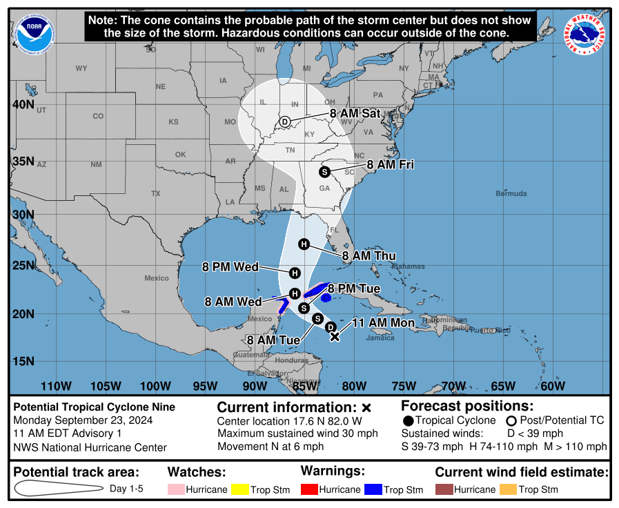
Location: 240 miles south-southeast of the western tip of Cuba
Maximum sustained winds: 35 mph
Movement: northwest at 8 mph
Pressure: 1,001 mb
Next advisory: 8 a.m.
Watches, warnings issued across Florida as Potential Tropical Cyclone 9 approaches
➤ Florida won’t be able to dodge Helene
Hurricane watch: A hurricane watch means that hurricane conditions are possible within the watch area. A watch is typically issued 48 hours before the anticipated first occurrence of tropical-storm-force winds.
Cabo Catoche to Tulum, Mexico
Cuban province of Pinar del Rio
Englewood to Indian Pass
Tampa Bay
Storm surge watch: A storm surge watch means there is a possibility of life-threatening inundation, from rising water moving inland from the coastline, in the indicated locations during the next 48 hours.
Tropical storm watch: An announcement that sustained winds of 39 to 73 mph are possible within the specified area within 48 hours in association with a tropical, subtropical, or post-tropical cyclone.
Dry Tortugas
Lower Keys west of the Seven Mile Bridge
Flamingo to south of Englewood
West of Indian Pass to Walton Bay County line
Tropical storm warning: A tropical storm warning means that tropical storm conditions are expected somewhere within the warning area within 36 hours.
Grand Cayman
Rio Lagartos to Tulum, Mexico
Cuban provinces of Artemisa, and Pinar del Rio, and the Isle of Youth
How strong is Potential Tropical Cyclone 9 and where is it going?
At 5 a.m. EDT, the disturbance was centered near latitude 18.9 North, longitude 83.0 West.
The system is moving toward the northwest near 8 mph. This general motion is expected later today and tonight, followed by a faster northward to north-northeastward motion on Wednesday and Thursday.
➤ Track all active storms
On the forecast track, the center of the system is forecast to move across the northwestern Caribbean Sea through tonight, and then over the eastern Gulf of Mexico on Wednesday and Thursday.
Maximum sustained winds are near 35 mph, with higher gusts.
Strengthening is expected during the next few days, and the system is forecast to become a hurricane on Wednesday and continue strengthening on Thursday as it moves across the eastern Gulf of Mexico.
Formation chance through 48 hours: high, near 100 percent.
Formation chance through 7 days: high, near 100 percent.
Spaghetti models for Potential Tropical Cyclone 9
Special note about spaghetti models: Illustrations include an array of forecast tools and models, and not all are created equal. The Hurricane Center uses only the top four or five highest performing models to help make its forecasts.
➤ Track Potential Tropical Cyclone Nine
Stay informed. Get weather alerts via textKey messages from the National Hurricane Center: What you need to know about Potential Tropical Cyclone Nine
The disturbance is forecast to intensify and be near hurricane strength when it reaches the far northwestern Caribbean Sea early Wednesday. Tropical storm conditions are expected over portions of western Cuba and the northeastern coast of the Yucatan Peninsula with hurricane conditions possible.
The system is expected to intensify into a major hurricane before it approaches the northeastern Gulf Coast on Thursday, and the potential for life-threatening storm surge and damaging hurricane-force winds along the coast of the Florida Panhandle and the Florida west gulf coast is increasing. Hurricane and storm surge watches have been issued, and residents should ensure they have their hurricane plan in place, and also follow advice given by local officials.
Potential Tropical Cyclone Nine will bring heavy rain to portions of the western Caribbean, which will cause considerable flooding and mudslides across western Cuba. Heavy rainfall will likely result in locally considerable flash and urban flooding across portions of Florida, with isolated flash and urban flooding possible across the Southeast, Southern Appalachians, and the Tennessee Valley Wednesday through Friday. Minor to isolated moderate river flooding will be possible.
Current forecast: Where is Potential Tropical Cyclone 9 going and how strong could it get?
As of 5 a.m.: 35 mph
12 hours: 45 mph
24 hours: 60 mph
36 hours: 75 mph
48 hours: 90 mph
60 hours: 115 mph
72 hours: 70 mph
96 hours: 15 mph
120 hours: dissipated
What impact could Potential Tropical Cyclone 9 have and what areas could be affected?
Wind: Hurricane conditions are possible within the watch areas in Cuba and Mexico by early Wednesday. Hurricane conditions are possible within the U.S. watch areas late Wednesday and early Thursday. Tropical storm conditions are expected in the warning areas in Cuba and Mexico beginning later today.
Tropical storm conditions are possible in the watch area beginning on Wednesday in southern Florida and the Keys, and Thursday in the Florida Panhandle.
Storm surge: The combination of a dangerous storm surge and the tide will cause normally dry areas near the coast to be flooded by rising waters moving inland from the shoreline. Storm surge could raise water levels by as much as 2 to 4 feet above normal tide levels in areas of onshore winds along the southern coast of Pinar del Rio, Cuba, including the Isle of Youth. Storm surge could raise water levels by as much as 2 to 4 feet above ground level in areas of onshore winds within the warning area along the east coast of the Yucatan Peninsula.
The water could reach the following heights above ground somewhere in the indicated areas if the peak surge occurs at the time of high tide:
Ochlockonee River, FL to Chassahowitzka, FL…10-15 ft
Chassahowitzka, FL to Anclote River, FL…6-10 ft
Indian Pass, FL to Ochlockonee River, FL…5-10 ft
Anclote River, FL to Middle of Longboat Key, FL…5-8 ft
Tampa Bay…5-8 ft Middle of Longboat Key, FL to Englewood, FL…4-7 ft
Englewood, FL to Bonita Beach, FL…3-5 ft Charlotte Harbor…3-5 ft
Rainfall: Potential Tropical Cyclone Nine is expected to produce total rain accumulations of 4 to 8 inches over western Cuba and the Cayman Islands with isolated totals around 12 inches. Over the eastern Yucatan Peninsula, 2 to 4 inches of rain is expected with isolated totals over 6 inches. This rainfall brings a risk of considerable flooding.
Over the Southeastern U.S., Potential Tropical Cyclone Nine is expected to produce total rain accumulations of 3 to 6 inches with isolated totals around 10 inches. This rainfall will likely result in areas of locally considerable flash and urban flooding, with minor to isolated moderate river flooding also possible.
➤ Excessive rainfall forecast
Surf: Swells generated by the system will affect the southern coast of Cuba and the Yucatan Peninsula of Mexico during the next couple of days. Swells will spread northward toward the west coast of Florida and the northeastern Gulf Coast on Wednesday and Thursday. These swells are likely to cause life-threatening surf and rip current conditions.
Expect to see new ‘cone of concern’ with next named storm, if it nears Florida, US
The National Hurricane Center first launched its new “cone of concern” for Hurricane Ernesto on Aug. 14.
Ernesto stayed well away from Florida and the U.S., so residents didn’t see many differences between the original and new cone. One of the biggest differences between the two is that the new cone will show wind warnings issued for interior counties, not just those on the coast.
Both cones will be visible on the Hurricane Center’s website. Find the new cone by going to the graphics page for the storm, then click on “New Experimental Cone,” which will be highlighted in red.
Differences you’ll see:
Watches and warnings for inland counties, not just coastal areas.
White transparent shading for the entire five-day forecast, instead of white stippling (dots) for the four- and five-day forecast.
Interactive map: What tropical storms, hurricanes have impacted your area in the past?What do the watches and warnings from NHC mean?
What is storm surge? Graphics explain the deadly weather event
Hurricane warning: A hurricane warning means that hurricane conditions are expected somewhere within the warning area. A warning is typically issued 36 hours before the anticipated first occurrence of tropical-storm-force winds, conditions that make outside preparations difficult or dangerous. Preparations to protect life and property should be rushed to completion.
Hurricane watch: A hurricane watch means that hurricane conditions are possible within the watch area. A watch is typically issued 48 hours before the anticipated first occurrence of tropical-storm-force winds, conditions that make outside preparations difficult or dangerous.
Tropical storm warning: A tropical storm warning means that tropical storm conditions are expected somewhere within the warning area within 36 hours.
Tropical storm watch: An announcement that sustained winds of 39 to 73 mph are possible within the specified area within 48 hours in association with a tropical, subtropical, or post-tropical cyclone.
Storm surge warning: A storm surge warning means there is a danger of life-threatening inundation, from rising water moving inland from the coastline, in the indicated locations. This is a life-threatening situation. Persons located within these areas should take all necessary actions to protect life and property from rising water and the potential for other dangerous conditions. Follow evacuation and other instructions from local officials.
Storm surge watch: A storm surge watch means there is a possibility of life-threatening inundation, from rising water moving inland from the coastline, in the indicated locations during the next 48 hours.
This article originally appeared on Tallahassee Democrat: Florida hurricane tracker: Spaghetti models, watches, warnings, impact
Source link : http://www.bing.com/news/apiclick.aspx?ref=FexRss&aid=&tid=66f29692194c421caeecc82b55990afc&url=https%3A%2F%2Fwww.yahoo.com%2Fnews%2Fhurricane-tropical-storm-watches-issued-095655379.html&c=1003447727053369013&mkt=en-us
Author :
Publish date : 2024-09-23 22:55:00
Copyright for syndicated content belongs to the linked Source.