The recent heat wave has broken. But don’t think we are returning to a typical cool fall pattern. The next round of warmer-than-normal temperatures is already shaping up and heading our way.
Just so you know, there is no long-lasting very cool weather anywhere in sight. If we get a cloudy, showery day, like tomorrow, we will have cool temperatures in the 60s. In general, however, we are looking at quite a few days in the next week with afternoon highs in the 70s. A few days topping 80 degrees will probably occur.
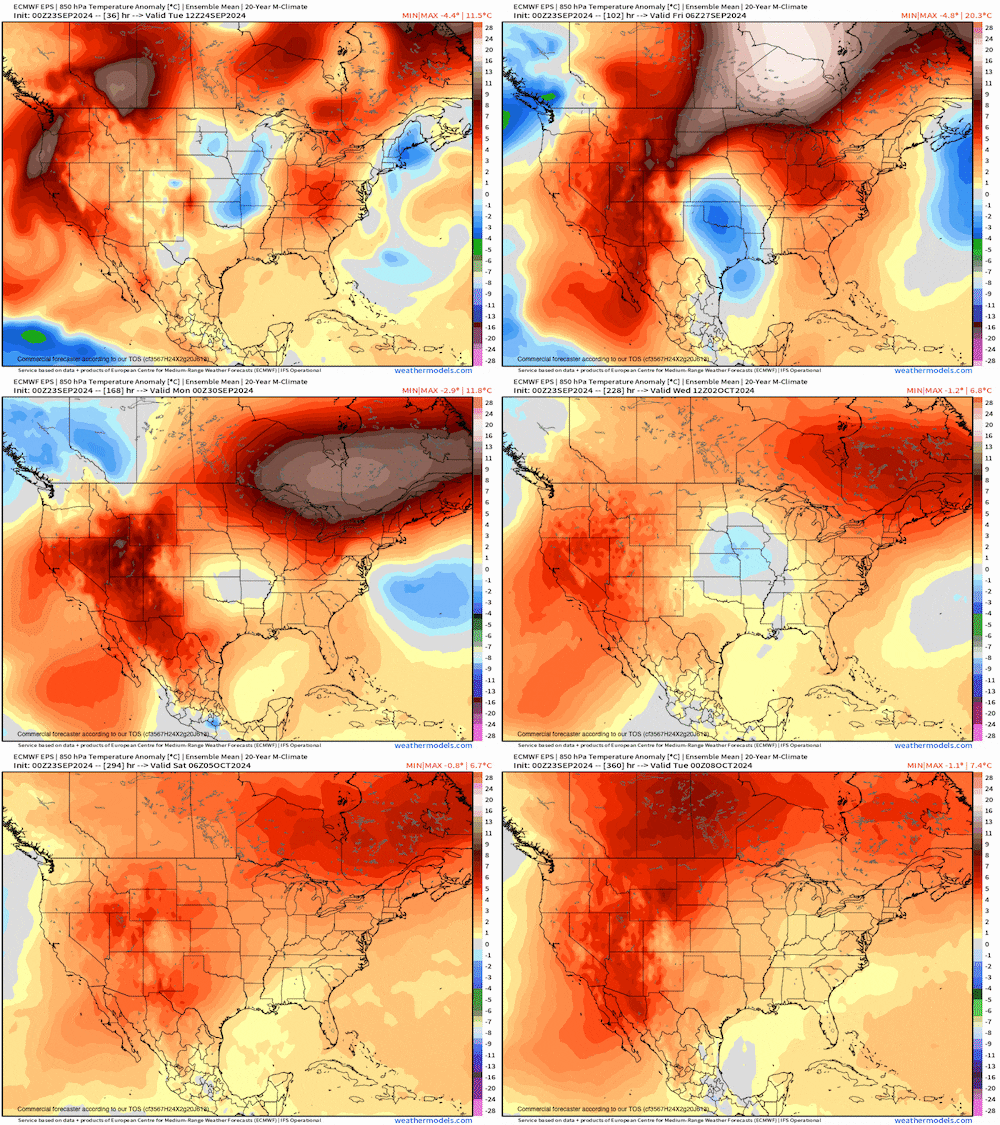
Look at the upper-level atmosphere forecast for the next 10 days. When you see orange or red it signifies a warmer than normal upper atmosphere. When the upper atmosphere is warm, our surface temperatures are also warmer than normal.

Temperature anomalies forecast at 5,000 feet up from Tuesday, September 24 to Monday, October 7, 2024NOAA
Notice you don’t see any blue, which means the upper atmosphere is always going to be warmer than normal through the first week of October. You also notice this weekend will have an extremely warm upper atmosphere for this time of year. The temperature at 5,000 feet up will be about 18 degrees warmer than normal. This temperature deviation usually transfers to the ground, bring us surface temperatures that will be 15 degrees to 20 degrees warmer than normal.
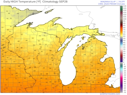
What is “normal” by this coming weekend? The image below shows you our average high temperatures on Sept. 28. Southern Michigan has averaged warming to around 68 degrees in late September. Northern Lower Michigan averages around 64 degrees.

Long-term average high temperature for September 28.NOAA
If we do the simple math on temperatures normally in the 60s and being 15 degrees to 20 degrees warmer than normal, we come up with this weekend warming to 80 degrees to 85 degrees.
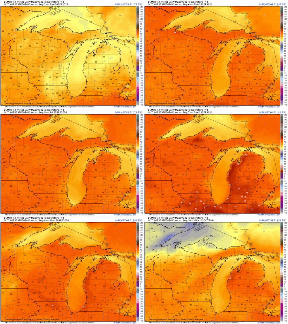
The forecast below are the high temperature forecasts into midweek next week. All days look to be in the 70s at least with 80s taking over this weekend into early next week.

High temperature forecast each day from Tuesday, September 24 to Wednesday, October 2NOAA
Of course, since we are looking at clouds and showers tomorrow, we will have temperatures held down into the 60s.
There is a tropical weather system developing in the Gulf of Mexico. If all goes as planned with that system, it is going to unfortunately become a hurricane and hit somewhere in the southeast U.S. When hurricanes hit the southeast U.S., they pump warm air our way and heat us up even more.
All of these things point to another summery stretch heading toward Michigan. It won’t be quite as hot as this last recent stretch, but it will be hot for the end of September and beginning of October.
Source link : http://www.bing.com/news/apiclick.aspx?ref=FexRss&aid=&tid=66f1bc5ff5504c919e7116e635ca05b4&url=https%3A%2F%2Fwww.mlive.com%2Fweather%2F2024%2F09%2Fthink-summer-heat-is-over-for-michigan-think-again.html&c=3657079223998831375&mkt=en-us
Author :
Publish date : 2024-09-23 07:50:00
Copyright for syndicated content belongs to the linked Source.