
(This story was updated to add new information.)
A brewing storm in the Caribbean Sea is forecast to strengthen into a hurricane in the Gulf of Mexico over the next few days and make landfall along the Gulf Coast as early as Thursday.
By Monday evening, the National Hurricane Center predicted the storm – still officially a “potential cyclone” but soon to be named Helene – will reach 115 mph before landfall, making it a “major” Category 3 storm. Tropical storm watches were hoisted late Monday for portions of the Florida Keys as the storm slowly moves north.
“Everyone along the Florida Panhandle and Big Bend region needs to be prepared for hurricane impacts,” said AccuWeather Lead Hurricane Expert Alex DaSilva, adding that the setup has the potential to become the strongest hurricane landfall in the U.S. so far this season.
WeatherTiger Meteorologist Ryan Truchelut put it succinctly in an online post: “Helene will come at you faster than you think, so go into hurricane mode now. While there remains uncertainty in both the track and intensity forecast, Florida isn’t getting out of this one.”
Florida Gov. Ron DeSantis on Monday declared a state of emergency for 41 counties along and near Florida’s Gulf Coast because of threats from the storm. The declaration said there’s a significant risk of storm surge and flooding, particularly in areas still recovering from the elevated water levels left behind by Hurricane Debby.
Most forecast models suggest a hurricane landfall in Florida or the northern Gulf Coast on Thursday, Weather.com meteorologist Jonathan Erdman said.
The system, elevated to “potential tropical cyclone nine” status Monday morning, will be named Helene once it becomes a tropical storm, which is expected to happen overnight.
Tropical storm warnings and hurricane watches were also issued for portions of western Cuba and the Yucatan Peninsula of Mexico.
Gulf Coast residents should prepare now, forecasters say
Unlike many hurricanes that track for days or weeks across the Atlantic Ocean, giving people ample warning for landfall, this one is forecast to develop and strengthen rapidly once it enters the Gulf of Mexico.
“Now is the time to start preparing for a hurricane landfall along the Gulf Coast. Don’t wait for this storm to be officially named,” AccuWeather meteorologist Jon Porter said.
He said there is the potential that this storm could further strengthen into a major hurricane, which is a Category 3 on the Saffir-Simpson Hurricane Wind Scale with maximum sustained winds of 111-129 mph.
This could be the storm that the 2024 hurricane season is remembered for, Porter said.
Track the storm: Tropical storm could form in Gulf of Mexico early this week
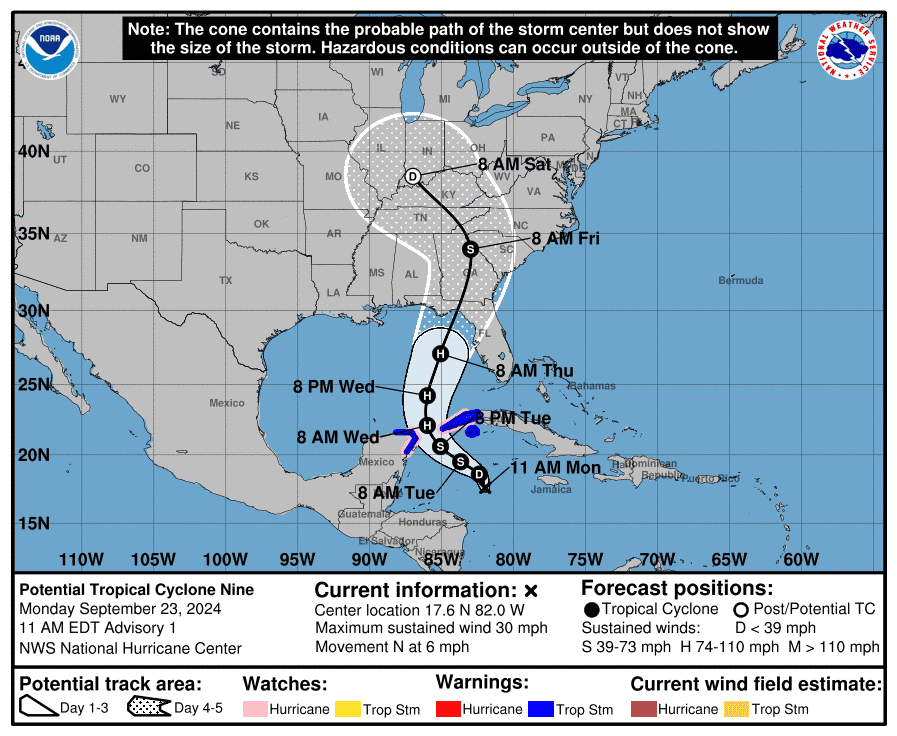
The forecast track of Potential Tropical Cyclone Nine, which is expected to become Tropical Storm and then Hurricane Helene over the next couple of days.
Where is the system now?
National Hurricane Center Deputy Director Jamie Rhome said in a Monday late afternoon update that the system was expected to become a tropical storm overnight.
“The latest trends and satellite imagery suggest that it’s starting to organize,” he said.
As of 5 p.m., the system was roughly 450 miles south of Key West, Florida.
Tropical storm force winds are expected across the Keys by 8 p.m. Wednesday, before it pushes northward across the rest of Florida overnight and into Thursday.
“The wind field with this system is going to be really large, larger than you’re used to seeing with a traditional hurricane and what that means is it’s going to push a big swath of storm surge across the western portions of the Florida peninsula,” Rhome said.
The Hurricane Hunters investigated the developing storm Monday, the center reported.
Storm could rapidly intensify into a formidable hurricane
Forecasters at the hurricane center warn that the system could intensify rapidly over the Gulf of Mexico.
The “environmental and oceanic conditions appear favorable for significant strengthening,” the hurricane center said in a Monday discussion. One model shows a 95% chance of the storm’s winds increasing by 75 mph or more over the next 72 hours, the center said.
The system is expected to strengthen into a hurricane by Wednesday.
Helene could become a formidable hurricane in the Gulf, according to Erdman, who said there is plenty of deep, warm water in the northwest Caribbean and parts of the Gulf of Mexico to power up the storm.
In fact, Erdman reported that Gulf of Mexico heat content is at record high levels for this time of year, according to University of Miami tropical scientist Brian McNoldy.
‘Taking all precautions:’ Florida farmers brace for hurricane
The storm threatened to make landfall just two weeks shy of the six-year anniversary of Hurricane Michael, which took a heavy toll on Panhandle farms, wiping out timber and other crops.
Jeff Pittman, a fourth-generation peanut and cotton farmer in Jackson County, Florida, watched the forecast with trepidation. Hurricane Michael damaged his peanut crop, destroyed his cotton crop, killed livestock and wrecked barns, fences and irrigation systems.
Pittman’s farm was preparing for the latest storm’s arrival. Just ten days into peanut harvesting season, he said they stopped the inverters that dig up the crop. He was also making sure generators were in place to supply water to his and his neighbors’ cows.
“We’re taking all precautions, everything we can think to do,” Pittman said. “We’re taking this very seriously. It looks like it could be a very serious situation come Thursday.”
What are the expected impacts from Helene?
Wind: Sustained winds of at least 115 mph are possible. Powerful wind gusts of up to 120 mph are expected where the storm makes landfall on Thursday.
Rain: Widespread 8-12 inches of rain are likely, potentially leading to “considerable” flooding. Rounds of rain will arrive as early as late Tuesday afternoon or early evening starting over the Keys and moving northward, according to the Florida Public Radio Emergency Network.
Power outages: Regional and localized power outages are expected across the Florida Panhandle and Big Bend region, as well as across much of Georgia, Alabama, southern Tennessee and pockets of far western South Carolina and North Carolina, AccuWeather said.
Tornadoes are also a major threat as the storm approaches later in the week.
High surf: In a marine forecast, the hurricane center warned it expects seas in the southeastern Gulf to reach 15 feet by Wednesday morning and peak at 25-30 feet on Thursday morning.
Storm surge also a serious threat
Storm surge will be a danger with the hurricane as it moves closer to the Gulf Coast. The highest chances for the deepest storm surge will be near where the storm makes landfall.
According to the hurricane center’s latest analysis, the swath of coast with locations that could see a 1 in 10 chance of a storm surge greater than 9 feet stretches along the entire coast from Cape Coral north to Alligator Point. The higher the wind speeds, the higher the potential storm surge could be.
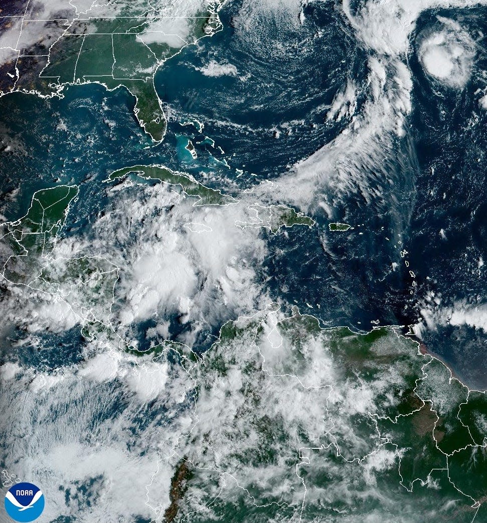
A storm system in the western Caribbean could become Tropical Storm Helene by Wednesday, Sept. 25, 2024.
Fourth landfalling hurricane this year?
If the storm makes landfall as a hurricane, it would be the fourth landfalling hurricane in the mainland United States this year, joining Beryl, Debby and Francine.
Three other years since 2000 have had four hurricane landfalls: 2004, 2005 and 2020, said Phil Klotzbach, senior research scientist at Colorado State University.
Storm trackerSpaghetti models for Caribbean systemExperts had predicted an ‘extraordinary season’
Federal forecasters earlier this year predicted an “extraordinary” season: As many as 24 named storms possible.
A typical season sees 14 named storms, based on weather records that date from 1991 to 2020.
Hurricane John threatens Mexico
In the Pacific Ocean, the hurricane center reported Hurricane John continues to strengthen as it moves closer to the coast of southern Mexico. The system is forecast to approach the southern coast of Mexico during the next day or two and move inland on Tuesday or Wednesday.
The center said “damaging hurricane-force winds, a dangerous storm surge and life-threatening flash flooding are expected in portions of southern Mexico.”
Hurricane names still to be used
The remaining Atlantic hurricane names for this season are:
Helene
Isaac
Joyce
Kirk
Leslie
Milton
Nadine
Oscar
Patty
Rafael
Sara
Tony
Valerie
William
Contributing: Dinah Voyles Pulver, USA TODAY; Cheryl McCloud, Ana Goñi-Lessan, James Call, USA TODAY Network; Jeff Burlew, Tallahassee Democrat
This article originally appeared on USA TODAY: Hurricane forecast calls for landfall along Gulf Coast this week
Source link : http://www.bing.com/news/apiclick.aspx?ref=FexRss&aid=&tid=66f22837451f4fa0b412e1e374dc2f31&url=https%3A%2F%2Fwww.aol.com%2Fhurricane-eyes-gulf-coast-landfall-145148581.html&c=1571252942769809457&mkt=en-us
Author :
Publish date : 2024-09-23 15:25:00
Copyright for syndicated content belongs to the linked Source.