The same storm responsible for drenching rain in parts of Montana and severe weather over the High Plains on Tuesday evening will press eastward into Thursday over the north-central United States. AccuWeather meteorologists say a new storm on its heels will create a large zone of drenching rain from Colorado to Minnesota this weekend, and there’s even a chance of the first snowfall of the season in parts of the Rockies.
As a storm pivots from Montana to south-central Canada into Thursday, additional rounds of thunderstorms are in store from the central and northern Plains to part of the Midwest. The main threat from the storms will be damaging wind gusts.
Into Wednesday night, thunderstorms capable of producing damaging wind gusts, hail and brief torrential downpours will extend from eastern Nebraska and western Iowa to the eastern part of the Dakotas and western Minnesota.
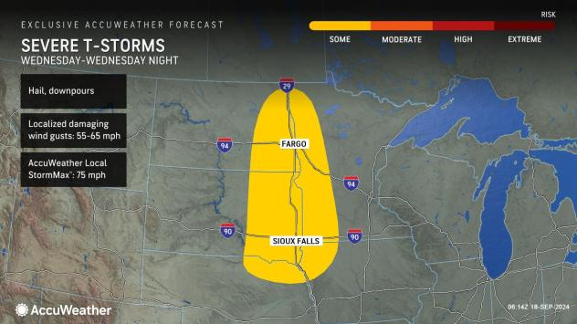

On Thursday afternoon and evening, the risk of severe thunderstorms will extend from eastern Minnesota, the western part of the Upper Peninsula of Michigan and central and western Wisconsin to much of Iowa, northern Missouri and northeastern Nebraska.
“The thunderstorm activity on Thursday may be more robust than Wednesday,” AccuWeather Senior Meteorologist Adam Douty said.
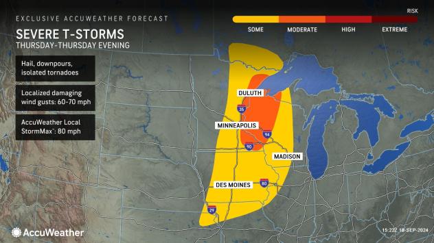

“Along with the likelihood of localized damaging wind gusts and brief downpours, there may be a few storms with hail. A few tornadoes cannot be ruled out in the strongest storms,” Douty added.
Soon after one storm leaves, a new storm will arrive from the Pacific Ocean.
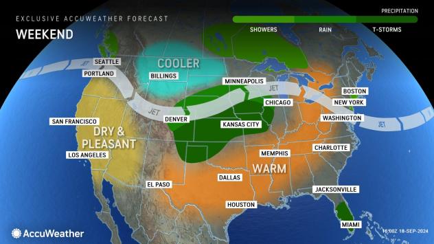
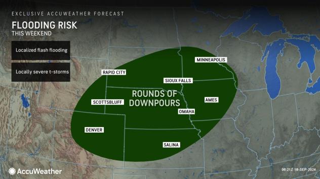
This weekend, the new storm will generate a vast swath of rain over 350,000 square miles, extending from the central Rockies to the upper Mississippi Valley. Rain is needed over a large portion of this zone due to drought. The storm has the potential to bring 1-3 inches of rain to many locations.

As is often the case during a drenching rain event, too much rain may pour down too fast for the ground or storm drainage systems to handle. Motorists venturing along Interstates 25, 29, 70 and 80, as well as U.S. Routes 6, 14, 20 and 83 should be prepared for a slow and slick ride for hundreds of miles.
GET THE FREE ACCUWEATHER APP
“Denver has the potential to pick up 1-2 inches of rain from the storm this weekend,” Douty said.

Snow becomes increasingly more common over the Rockies in September and October with some of the biggest storms of the snow season tending to occur as bookends in the fall and spring. This has to do with the availability of moisture from the Gulf of Mexico in the fall and spring, as opposed to the dry winds from the north in the middle of the winter. During the middle of the winter, the jet stream is usually well to the south of the region, rather than nearby like during the fall and spring.
“With this storm at elevations of 8,500-9000 feet and above in northern Colorado, there is a chance of accumulating snow from late Saturday night to Sunday,” AccuWeather Senior Meteorologist Brett Anderson said. Travel could be slow and slippery due to slushy snow along I-70 near the Eisenhower Tunnel.
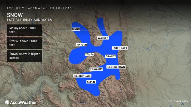

Temperatures will be too high for snow around the Denver metro area and foothills, but the thermometer will climb no higher than the 50s F. The rain may be heavy enough and visibility low enough to lead to airline delays at the major hub in the central U.S. Flooding in poor drainage areas is possible.
Other cities in the Central states may be affected, mostly by thunderstorms. Minneapolis could experience two rounds of thunderstorms with one batch from Thursday afternoon to evening and another on Sunday afternoon, just ahead of the drenching rain. Chicago could experience its first downpour of the month on Monday from thunderstorms. There was a few hundredths of an inch of rain back on Sept. 5.
South and east of the weekend storm track, thunderstorms will erupt. Some may be severe, packing high winds, hail and torrential downpours.
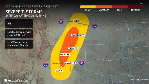

The risk of severe weather will progress farther to the east on Sunday.
The extended period of dry weather throughout the Plains and Mississippi Valley region has left a buildup of oils and other chemicals on roads that can be especially slippery when rain begins to fall. A higher number of accidents could result.
The many weeks of dry conditions have left the ground dry and have caused stream and river levels to drop. The runoff will eventually find its way into the Mississippi River, where water levels were nearing critically low levels for the third year in a row.


Rain at harvest time is not usually welcomed in the region, and field operations could be more difficult in the wake of the storm with muddy soil conditions.
Want next-level safety, ad-free? Unlock advanced, hyperlocal severe weather alerts when you subscribe to Premium+ on the AccuWeather app. AccuWeather Alerts™ are prompted by our expert meteorologists who monitor and analyze dangerous weather risks 24/7 to keep you and your family safe
Source link : http://www.bing.com/news/apiclick.aspx?ref=FexRss&aid=&tid=66eb13b0247242b3b25916677ca92ea0&url=https%3A%2F%2Fwww.aol.com%2Fweather%2Fbig-storms-hammer-north-central-165802060.html&c=8463529314988722351&mkt=en-us
Author :
Publish date : 2024-09-18 05:58:00
Copyright for syndicated content belongs to the linked Source.