Tropical Storm Francine formed in the Gulf of Mexico on Monday and could be a Category 2 hurricane with 100 mph winds as it approaches landfall along the Louisiana coast on Wednesday afternoon.
“Francine is expected to bring heavy rainfall and the risk of considerable flash flooding along the coast of northeast Mexico, the far lower and far upper Texas coasts, southern Louisiana, and southern Mississippi into Thursday morning,” the National Hurricane Center said.
Life-threatening storm surge and other dangerous conditions could occur along parts of coastal areas, the center warned.
Louisiana Governor Jeff Landry declared a state of emergency Monday, a precautionary measure before hurricanes to allow the movement of resources. “We want everyone in the state to be cautious and vigilant,” Landry said. “We don’t want to downplay this event, but we also don’t want people to panic.”
Landfall is expected along Louisiana’s coast on Monday afternoon roughly somewhere between the Texas border and Port Fourchon. A significant storm surge also is expected along the Texas and Louisiana coasts, with the greatest surge expected near landfall and to the east.
Heavy rain and damaging wind gusts could lead to downed trees, power outages and structural damage from portions of northeastern Mexico to the southern U.S., AccuWeather warned. Because of recent rains, considerable flash flooding and urban flooding is possible through Thursday morning in southern Louisiana and Mississippi.
Francine strengthened and became better organized on Monday and appeared to be forming an eye on satellite images, hurricane center director Michael Brennan said in an afternoon briefing. Hours later, however, it appeared the storm pulled in dry air , which delayed further strengthening, at least temporarily, the hurricane center said in a 10 p.m. CDT discussion.
The center of the system was an estimated 125 miles south-southeast of the mouth of the Rio Grande and about 420 miles south-southwest of Cameron, Louisiana, at 10 p.m. CDT Wednesday, still with sustained winds of 65 mph and moving north-northwest at about 5 mph.
The official forecast calls for it to become a hurricane on Tuesday morning, Brennan said. Tropical storm-force winds extend up to 140 miles away from the center of the storm. Francine is forecast to continue strengthening as it approaches landfall on Wednesday, but then encounter wind shear along the coast.
Sweeping watches and warnings are in effect along the Gulf Coast from High Island, Texas, to the Mississippi-Alabama border. The southeast coast of Texas is expected to receive “some pretty significant rainfall over the next 12-24 hours,” Brennan said.
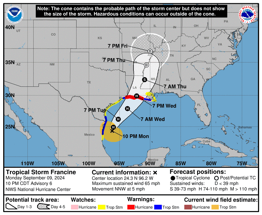

Tropical Storm Francine is expected to become Hurricane Francine on Tuesday, drenching a swath of coast from Texas to Mississippi with flash flooding and life-threatening storm surge as it makes landfall Wednesday. This graphic shows the likely path of the center of the storm, and not the full impacts.
Watches and warnings in effect
A hurricane warning was issued Monday afternoon for the Louisiana coast from the Texas border east to Morgan City, Louisiana, meaning hurricane conditions are expected within 36 hours.
A hurricane watch is in effect further east on the Louisiana coast from Morgan City east to Grand Isle, meaning hurricane conditions are possible there within the next 48 hours.
A tropical storm warning, meaning tropical storm conditions are expected within 36 hours, is in place along the Louisiana coast from east of Morgan City to Grand Isle, Louisiana and from High Island, Texas to Sabine Pass.
A tropical storm watch is in effect along the Texas coast from Barra del Tordo, Mexico north to High Island, Texas, and from east of Grand Isle, Louisiana, to the mouth of the Pearl River, including Lake Pontchartrain. A watch means tropical storm winds are possible along the coast by Tuesday evening.
An elevated risk of rip currents is expected along Gulf Coast beaches this week as Francine approaches the coast, according to the National Weather Service.
In preparation for potentially rough wind and seas, two U.S. oil and gas producers in the Gulf of Mexico are evacuating staff and curbing drilling, Reuters reported Monday.
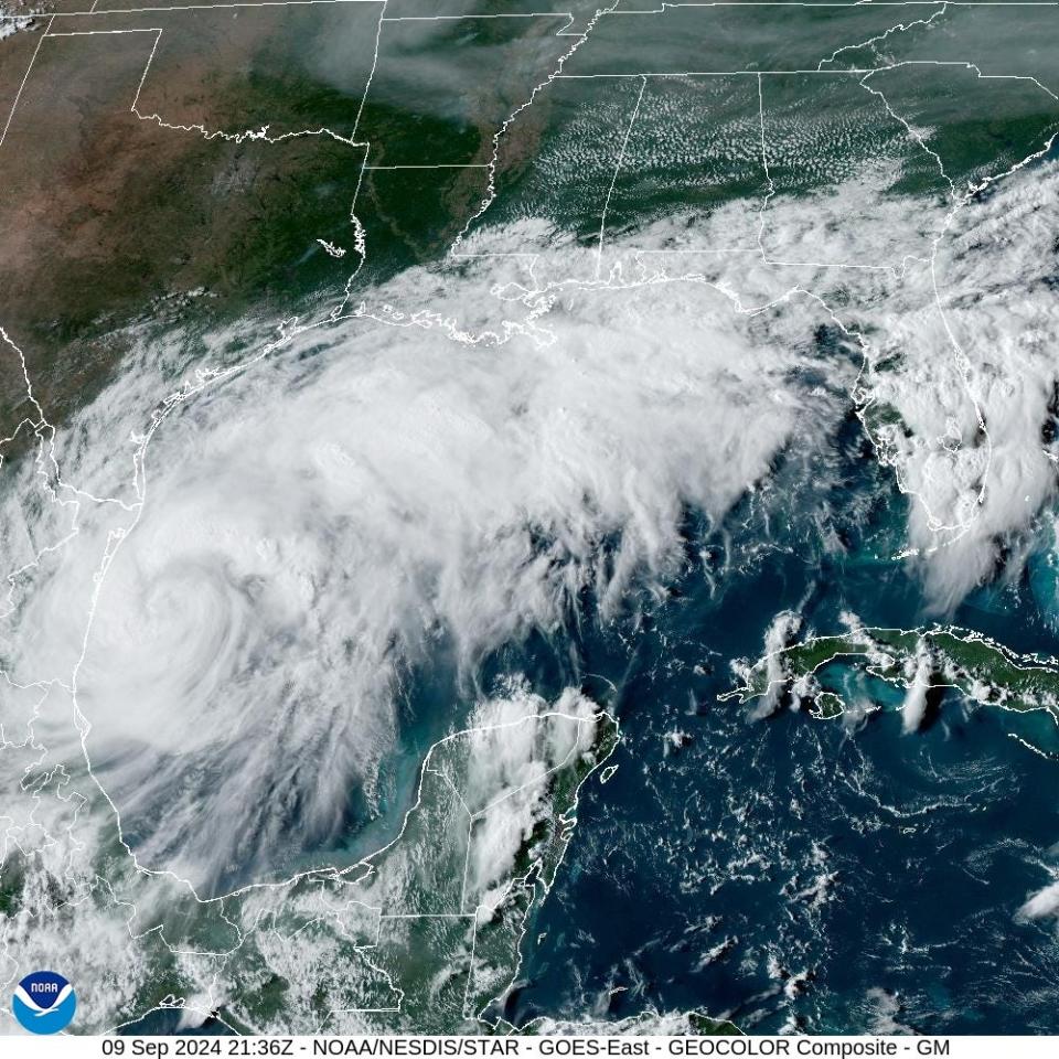

Tropical Storm Francine continued to get stronger and better organized on Monday, Sept. 9, 2024 as it moved slowly northward in the Gulf of Mexico.
Francine is the sixth named storm of the season
Francine is the sixth named storm of the 2024 Atlantic hurricane season, and the first since Ernesto dissipated on Aug. 20.
The system is one of three the hurricane center is watching. Another is in the central tropical Atlantic and is given a 40% chance of becoming a tropical storm within 48 hours. A storm farther to the east has a 70% chance of development over the next week.
The center’s forecast calls for Francine to be a Category 2 hurricane with 100 mph winds as it nears the coast on Wednesday with 100-mph winds.
The storm is forecast to bring 4–8 inches of rainfall to the coast. Amounts up to 12 inches are possible in some locations in northeastern Mexico and along the Texas and Louisiana coasts through Thursday, presenting a flash flood risk, the center said.
The first Hurricane Hunter flight flew into Francine on Monday afternoon, a crew aboard the National Oceanic and Atmospheric Administration’s Gulfstream IV jet, dubbed Gonzo. And other flights are scheduled to fly regularly as the storm approaches land.
Where are the strongest winds expected?
Francine is forecast to begin a faster motion to the northeast by late Tuesday as it meets a cold front along the Gulf Coast. It would be just offshore along the Texas coast moving toward a potential landfall along the upper Texas or Louisiana coast on Wednesday afternoon, said Donald Jones, a meteorologist in the National Weather Service office in Lake Charles, Louisiana in a Sunday night briefing.
The greatest probability for tropical storm force winds – 70 – 80% chance – is across the coastal areas of Vermilion, Iberia, St. Martin and St. Mary parishes, Jones said. Hurricane watches were issued along the Louisiana coast from the eastern half of Cameron Parish east across the central coast of Louisiana. Those probabilities are expected to rise as Francine edges closer.
“We always like to say prepare for one category higher than forecast,” Jones said. There’s a chance Francine could hit maximum strength before landfall and stop intensifying as it interacts with the cold front along the coast, Jones said.A storm surge watch was issued for the coast just west of Sea Rim State Park in southeast Texas and east to Morgan City, Louisiana, with a possibility of storm surge 3 feet or greater.
“We’re looking at a peak storm surge of 5 to 10 feet from Cameron, Louisiana east to Port Fourchon,” Jones said. Surf of 4–7 feet is possible from Port Fourchon east along Louisiana’s southern coast.
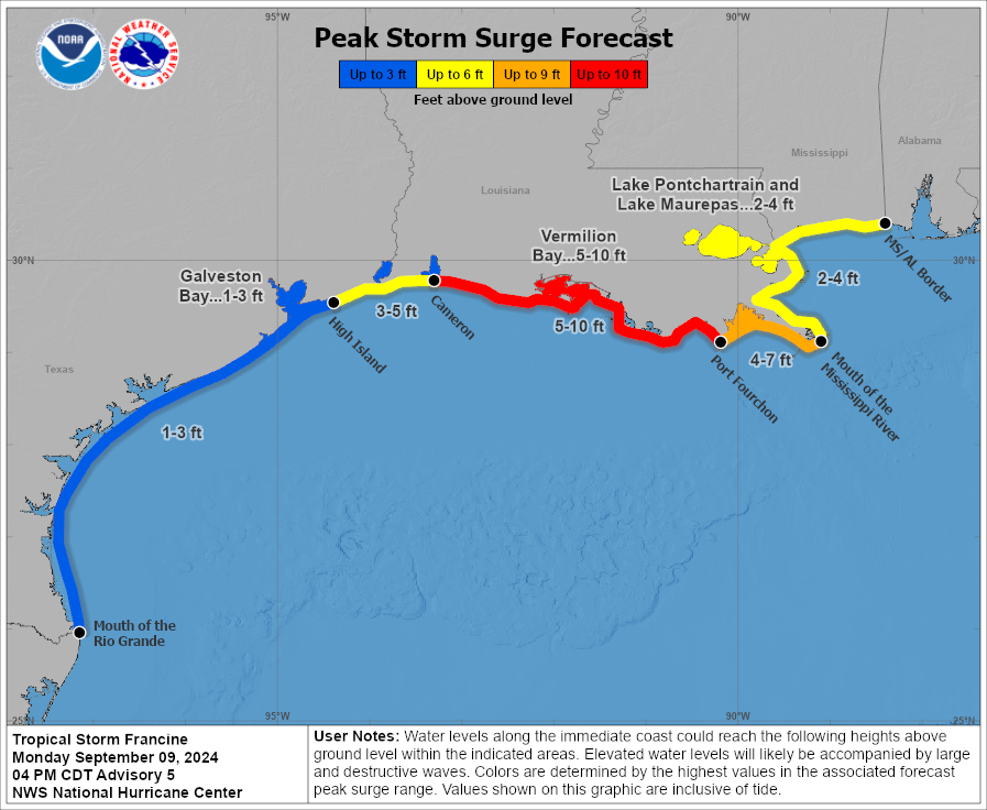

A peak storm surge of up to 10 feet, if landfall occurs near high tide, is forecast along parts of the Central Louisiana coast on Wednesday, the National Hurricane Center said.
Francine could become a Category 2
Jones urged residents in Southwestern Louisiana to keep an eye on the weather and have their storm preparations complete by Wednesday morning. “We’re going to be looking at 8 to 12 inches of rainfall south of Interstate 10 in southwestern Louisiana,” he said.
Once the system forms a well-defined center, the hurricane center said strengthening is possible. The storm would be over the warm Gulf in an area of abundant moisture, the hurricane center said, but could encounter an increase in wind shear and slightly drier air that could prevent significant strengthening.
Oil platforms preparing for Francine
Exxon Mobile said it was reducing its drilling output and evacuated staff from its Hoover offshore production team, while Shell said it was pausing drilling operations at its Perdido and Whale offshore platforms on Monday, Reuters reported
This article originally appeared on USA TODAY: Tropical Storm Francine forms, could be hurricane before US landfall
Source link : http://www.bing.com/news/apiclick.aspx?ref=FexRss&aid=&tid=66dfe46ac8654c5cb0e3a9ba31a59403&url=https%3A%2F%2Fwww.yahoo.com%2Fnews%2Ftropical-system-could-hurricane-wednesday-043032156.html&c=18269104923619772074&mkt=en-us
Author :
Publish date : 2024-09-09 17:02:00
Copyright for syndicated content belongs to the linked Source.