This Tuesday morning, Tropical Storm Francine has maintained 65 mph sustained winds, just short of hurricane strength. According to the National Hurricane Center (NHC), Francine’s structure has not improved overnight, which is a sign the storm has not strengthened much over the past few hours. A Hurricane Hunters aircraft is heading toward the storm, which will give us a better idea of the current strength of Francine.
Here is a complete breakdown of what you need to know about Francine and any potential impacts on Texas:
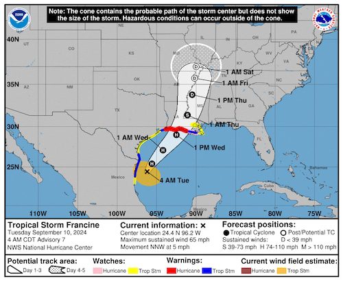
National Hurricane Center (NHC) Advisory 7 update on Tropical Storm Francine valid at 4 a.m. on Tuesday, Sept. 10, 2024.National Hurricane Center, NOAA
Hurricane warnings have been issued for the extreme eastern Texas coast from High Island to Port Arthur, and for nearly the entire Louisiana coast. Storm surge warnings have also been issued for these locations.
On the Texas coast, 1-3 feet of storm surge is expected from the Rio Grande to High Island. From High Island to Calcasieu Lake, between 3-5 feet of storm surge is expected. For much of the Louisiana coast, a rise of water by 5-10 feet is expected there. Click here for an interactive and more in-depth look at the potential storm surge for your location.
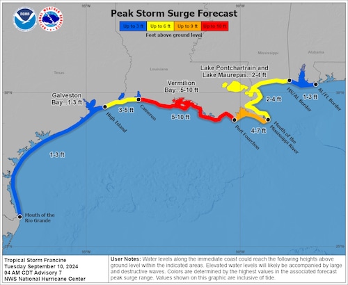
NHC Peak Storm Surge forecast valid at 4 a.m. on Tuesday, Sept. 10.National Hurricane Center, NOAA
The latest forecasts continue to show Francine increasing strength and becoming a hurricane over the next 12-24 hours. Most folks in Texas will deal with breezy to gusty winds at or below tropical storm force due to the proximity of Francine. Only the Port Arthur area will have a chance at seeing hurricane force winds.
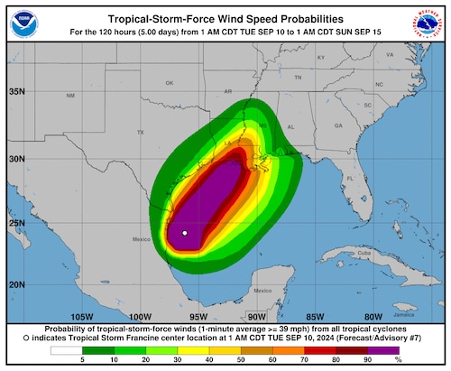
NHC tropical-storm-force wind speed probabilities predictions from Tropical Storm Francine.National Hurricane Center, NOAA
Between 2 to 5 inches of rain have fallen in South Texas, with additional rain expected over the next five days. Fortunately for Texans, the greatest rainfall amounts will likely miss the state, which is lowering the flash flood threat for our coastline. The latest NHC five-day rainfall predictions outline the possibility of seeing a measly 2 to 4 inches of rain, compared to the 6 to 10 inches expected for parts of Louisiana.
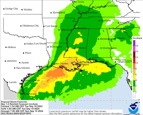
5-day rainfall forecast for Tropical Storm Francene.National Hurricane Center, NOAA
Francine will continue to move to the northeast over the next several hours, with landfall expected sometime Wednesday afternoon along the central Louisiana coast. The upper level weather patterns are saving Texans from the brunt of the impacts from Francine.
Both the southernmost and easternmost shores will have some gustier and rainier weather, but our major cities are looking to stay in the clear. Check out the projected wind speeds and movement of Francine as it heads towards Louisiana below.
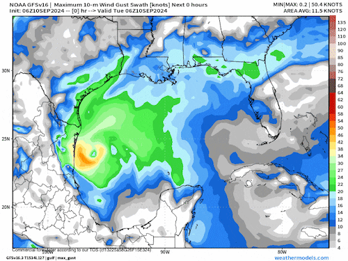
One model’s prediction of the maximum wind speeds from Tropical Storm Francine over the next 64 hours.NOAA
While Texans may be avoiding the worst of this storm, we can still see more tropical activity over the next two months. We will be sure to update you if any changes in the forecast bring more significant weather to the Lone Star State today or in the future. Check back here on Lonestarlive.com to stay on top of the tropics right here in Texas.
Source link : http://www.bing.com/news/apiclick.aspx?ref=FexRss&aid=&tid=66e046d45f8e4b6c87f1b7ff31523ab2&url=https%3A%2F%2Fwww.gulflive.com%2Fweather%2F2024%2F09%2Fhurricane-warnings-in-effect-for-eastern-texas-louisiana-as-francine-nears.html&c=10629411507840795730&mkt=en-us
Author :
Publish date : 2024-09-10 01:33:00
Copyright for syndicated content belongs to the linked Source.