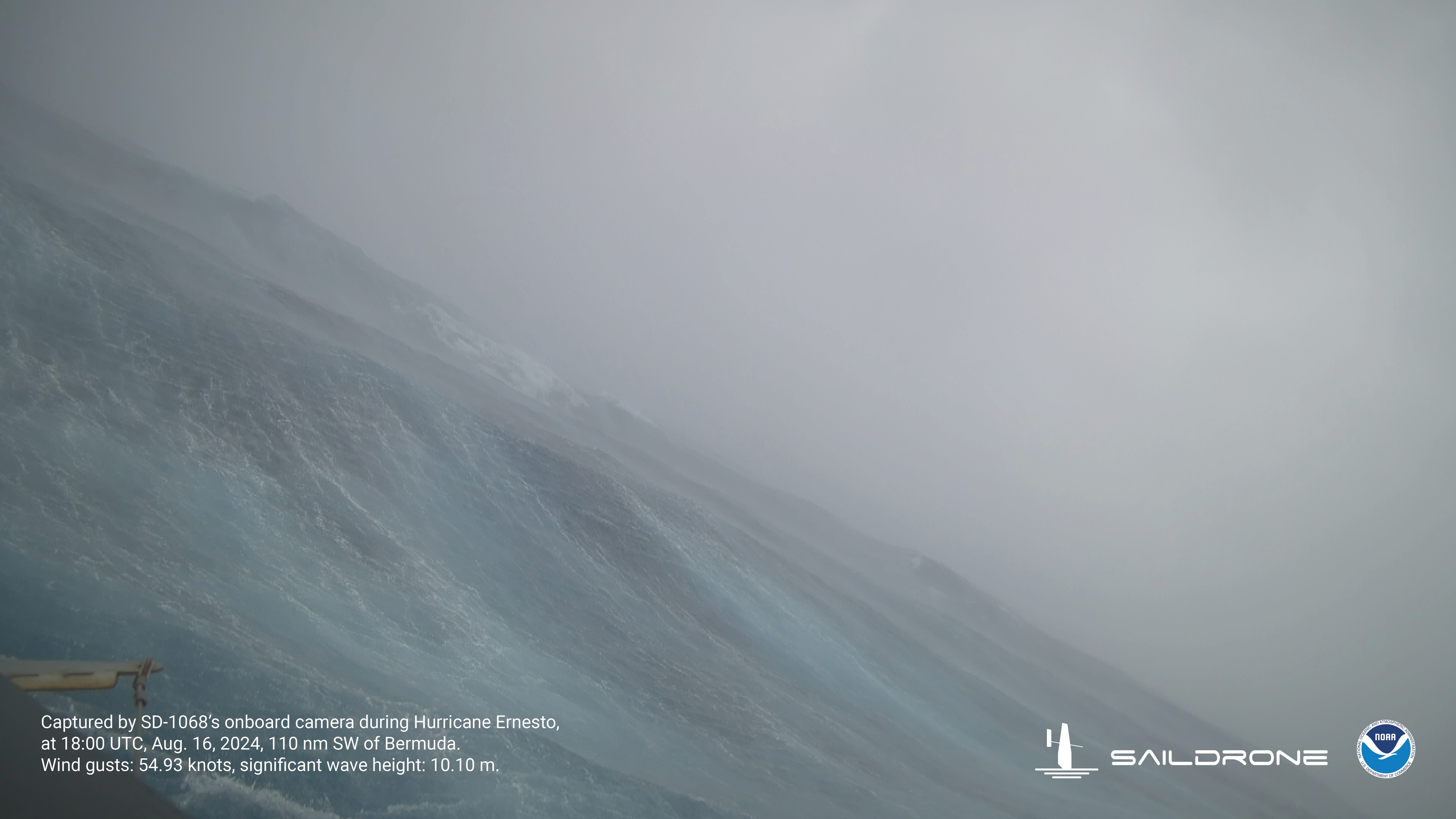
Saildrone sails into Hurricane Ernesto’s big waves
The Saildrone Explorer intercepted Hurricane Ernesto on Aug. 15, capturing high seas with the average of the highest third of waves at 26.5 feet.
Provided by Saildrone and NOAA
The National Hurricane Center reported that Hurricane Ernesto made landfall in Bermuda at 4:30 a.m. Saturday, bringing Category 1, 85 mph winds from a system weakened by dryer air.
The island in the Atlantic is expected to be lashed by strong winds all day Saturday with heavy rains resulting in possible flash flooding.
Ernesto also is forecast to bring dangerous swells and life-threatening rip currents to Florida and along the entire East Coast of the U.S. through the weekend.
➤ Track Hurricane Ernesto
➤ Weather alerts via text: Sign up to get updates about current storms and weather events by location
In its 5 p.m. Saturday forecast, the National Hurricane Center said the eye of Hurricane Ernesto was inching away from Bermuda. The island in still under a tropical storm warning, and the storm is expected to spin near the island for much of Saturday, moving off early Sunday and keeping a north-northeastern track as a hurricane in the Atlantic over the next few days.
The formation of the latest storm of the 2024 Atlantic hurricane season came just over a week after Hurricane Debby made landfall on Florida’s Big Bend Monday, Aug. 5.
What is the short-term hurricane forecast?
There are no threats on the horizon in the wake of Ernesto, according to Ryan Truchelut, a Florida meteorologist who works with the USA TODAY Network.
“While many supportive factors for storm development are in place, the Atlantic remains awash in enough dry air and Saharan dust to exsanguinate tropical waves for now. This should change sometime in the last week of August,” Truchelut predicts.
National Hurricane Center launches new ‘cone of concern’ with Hurricane Ernesto
The National Hurricane Center launched its new “cone of concern” for Hurricane Ernesto Thursday, Aug. 14.
You won’t see many differences between the original and new cone with Ernesto since one of the biggest differences is that the new cone will show wind warnings issued for interior counties, not just those on the coast.
Both cones are visible on the Hurricane Center’s website. Find the new cone by going to the graphics page for Hurricane Ernesto, then clicking on the New Experimental Cone highlighted in red.
Differences you’ll see:
Watches and warnings for inland counties, not just coastal areas.White transparent shading for the entire five-day forecast, instead of white stippling (dots) for the four- and five-day forecast.Hurricane Ernesto: What you need to knowLocation: 85 miles northeast of Bermuda; 1,090 miles southwest of Cape Race, NewfoundlandMaximum sustained winds: 75 mphMovement: North-northeast at 6 mphNext advisory: 8 p.m.Watches, warnings issued for Florida, US
No watches or warning directly connected to Hurricane Ernesto have been issued for Florida. However, rip current statements and small craft advisories have been issued along most of Florida’s East Coast as swells from Ernesto reach the coast.
A tropical storm warning has been issued for:
A tropical storm warning means that tropical storm conditions are expected somewhere within the warning area.
Interests in southeastern Newfoundland should monitor the progress of Ernesto.
How strong is Hurricane Ernesto and where is it going?
At 5 p.m. AST Saturday, the center of Hurricane Ernesto was located near latitude 33.3 North, longitude 64.0 West.
Ernesto has slowed down throughout the afternoon, currently moving northeast near 6 mph.
➤ Track all active storms
Spaghetti models for Hurricane Ernesto
Special note about spaghetti models: Illustrations include an array of forecast tools and models, and not all are created equal. The Hurricane Center uses only the top four or five highest performing models to help make its forecasts.
➤ Hurricane Ernesto
Stay informed. Get weather alerts via textPredicted impact on Florida from Hurricane Ernesto
Beachgoers along the U.S. East Coast can expect a “high risk of dangerous rip currents, through the weekend” the Hurricane Center said.
Swells were expected to be on the east coast of the United States through the weekend. These swells are likely to cause life-threatening surf and rip current conditions. Those swells are expected all the way up the U.S. coast and in Atlantic Canada.
“Entering the hazardous surf is strongly discouraged,” the National Weather Service Melbourne said.
The conditions have already resulted in deaths along the coast of the United States.
Two people died in separate rip current incidents on Friday on Hilton Head Island South Carolina. The National Weather Service Charleston said emergency management reported a death caused by a rip current at 10:22 a.m. Friday at Forest Beach and another at Folly Field Beach at 3:22 p.m.
Ernesto Florida impacts: Hurricane Ernesto may affect your Florida beach plans. Here’s timeline and what to expect
Key messages from the National Hurricane Center: What you need to know about Hurricane ErnestoErnesto is moving slowly, and its impact on Bermuda are not over. Strong winds, heavy rainfall, coastal flooding and battering winds are likely through tonight. The heavy rains will likely result in considerable life-threatening flash flooding, especially in the low-lying areas on the island.Even though Ernesto is forecast to remain well offshore of the U.S. East Coast, swells generated by the hurricane are expected to affect the area through early next week. Beachgoers should be aware that there is a significant risk of life-threatening surf and rip currents, and should stay out of the water if advised by lifeguards. Surf and rip currents are also possible on the Bahamas, Bermuda and Atlantic Canada during the next few days.Ernesto could bring wind, wave and rain impacts to portions of southeastern Newfoundland late Monday and Monday night.Radar: Watch as Hurricane Ernesto approaches BermudaWhat else is out there and how likely are they to strengthen?
The National Hurricane Center was not tracking any other disturbances at 5 a.m. Saturday.
Interactive map: What tropical storms, hurricanes have impacted your area in the past?When is the Atlantic hurricane season?
The Atlantic hurricane season runs from June 1 through Nov. 30.
When is the peak of hurricane season?
The peak of the season is Sept. 10, with the most activity happening between mid-August and mid-October, according to the Hurricane Center.
Excessive rainfall forecastWhat’s next?
We will continue to update our tropical weather coverage daily. Download your local site’s app to ensure you’re always connected to the news. And look for our special subscription offers here.
Contributing: Dinah Voyles Pulver, USA TODAY
Source link : http://www.bing.com/news/apiclick.aspx?ref=FexRss&aid=&tid=66c114dc1f1a4f03a2306b78e93b0dbb&url=https%3A%2F%2Fwww.statesman.com%2Fstory%2Fweather%2Fhurricanes%2F2024%2F08%2F17%2Fhurricane-ernesto-bermuda-florida-rip-currents%2F74830029007%2F&c=12311191634952354838&mkt=en-us
Author :
Publish date : 2024-08-17 00:02:00
Copyright for syndicated content belongs to the linked Source.
