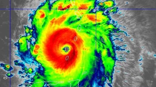
Record-breaking Hurricane Beryl charges west toward Jamaica
AccuWeather forecasters say Beryl will still be a major hurricane when it slams into Jamaica, but will weaken before it makes it to the eastern coast of Mexico.
Hurricane Beryl made landfall on Monday on Grenada’s Carriacou Island hours after strengthening into a Category 4 storm.
The National Hurricane Center said data from an Air Force Reserve Hurricane Hunter aircraft indicate that Beryl’s maximum sustained winds have increased to 150 mph. In its latest advisory, the NHC also said life-threatening winds and dangerous storm surge conditions are occurring in Grenada, the Grenadine Islands and Carriacou Island and that residents “should not leave their shelter.”
NHC forecasters said Beryl is expected to move quickly westward to west-northwestward during the next few days. The storm is expected to move across the southeastern and central Caribbean Sea late Monday through Wednesday.

Tracking Beryl across the Caribbean
Monitor Hurricane Beryl as it treks across the Caribbean and see which regions could be impacted. The storm will not impact Florida or the East Coast.
Beryl was briefly a Category 3 hurricane Monday morning before re-strengthening into a Category 4 hurricane with maximum sustained winds near 130 mph, according to the NHC.
“Fluctuations in strength are likely during the next day or so, but Beryl is expected to remain an extremely dangerous major hurricane as its core moves through the Windward Islands into the eastern Caribbean,” the NHC said in its 11 a.m. ET advisory.
The NHC also said some weakening is expected in the central Caribbean by midweek, although Beryl is forecast to remain a hurricane.
Hurricane Beryl live updates: ‘Potentially catastrophic’ Hurricane Beryl poised for landfall

Caribbean braces for “life-threatening” winds from Hurricane Beryl
Hurricane Beryl will bring life-threatening storm surge and winds. It is the third earliest Atlantic major hurricane on record.
Tropical Storm Chris makes landfall in Mexico
In addition to Beryl, the NHC is also tracking Tropical Storm Chris, which made landfall in Mexico early Monday morning, bringing heavy rain and flooding to portions of eastern Mexico.
The NHC said Chris is moving west at about 12 mph, and is expected to continue doing so over the next day or so. The NHC also says the center of Chris will continue farther inland over Mexico through Monday, and that the system will likely dissipate later today.
Invest 96L likely to become tropical depression
Elsewhere in the Atlantic, the NHC is tracking showers and thunderstorms associated with an “area of low pressure” located about 1,000 miles west-southwest of the Cabo Verde Islands.
The storm system, named Invest 96L, is likely to become a tropical depression by the middle of this week as it moves westward across the central and western tropical Atlantic, according to the NHC.
Atlantic storm trackerHurricane Beryl path tracker
This forecast track shows the most likely path of the center of the storm. It does not illustrate the full width of the storm or its impacts, and the center of the storm is likely to travel outside the cone up to 33% of the time.
Hurricane Beryl spaghetti models
Illustrations include an array of forecast tools and models, and not all are created equal. The hurricane center uses only the top four or five highest performing models to help make its forecasts.
Contributing: Cheryl McCloud, USA TODAY Network-Florida; Susan Miller & John Bacon, USA TODAY
Gabe Hauari is a national trending news reporter at USA TODAY. You can follow him on X @GabeHauari or email him at Gdhauari@gannett.com.
Source link : https://www.usatoday.com/story/news/weather/2024/07/01/hurricane-beryl-tracker-projected-path/74265690007/
Author :
Publish date : 2024-07-03 07:30:15
Copyright for syndicated content belongs to the linked Source.
